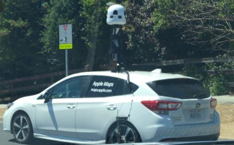
At the beginning of the year, Apple officially finished reconstructing Apple Maps in the US. Yet, it’s constantly improving its map data and map-based features. Recently, some important details about how Apple operates its mapping vehicles and how it manages the data they capture were shared.
The company’s 3D Vision team cruises around in a fleet of white Subaru Imprezas. The vehicles are filled with high-res cameras and LiDAR scanners that merge computer vision and machine learning data to generate 3D images on Apple Maps. All of that data is processed by a 2013 Mac Pro and stored in four SSDs with 4TB of storage each. Those can hold up to about of week of mapping data, and Apple uses UPS to transport the SSDs back to its offices.

Normally, one person drives the car while the other operates the EyeDrive system — an iPad equipped with the EyeDrive app, which feeds routes and driving instructions. The vehicles must be driven in perfect weather conditions, and they must start capturing in the morning when the sun is at 30 degrees and drive until dusk when the sun returns to 30 degrees.
According to 9to50Mac, the information is basically used for features like Flyover and Look Around. The vehicles are mostly spotted in the US, but Apple is allegedly expanding them to Canada, Europe, and Japan.
Apple Maps is still struggling with its reputation as an internet punchline. Back in 2018, it promised to fix its Maps by using its own data, and we’ve seen it put in the necessary legwork. Ever since the company finished rebuilding its Map data, it has rolled out useful features. It now displays COVID-19 testing sites and is using Map data to help public health officials.
TECH NEWS>>>Beats Solo Pro Headphones Are Surprisingly Cheaper On Amazon


